Fully-licensed Operators
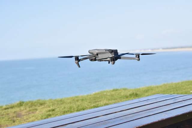
All surveys are conducted by certified operators recognized by the Civil Aviation Authority of the United Kingdom and backed by engineers and GIS analysts.
Comprehensive & Tailored Solutions
Every project is different. Our huge range of solutions are tailored for each client’s needs to make sure you get the practical data you need.

AthelstanOne-wide Services
Our partner commercial drone companies operate across London, Manchester, and Sheffield. Aerial surveys are always available across United Kingdom, Nigeria and South Africa.
Available AthelstanOne Drone Network services:
Below are examples of services we regularly provide for local clients in United Kingdom, Nigeria, and South Africa:
Project Site Monitoring
Regular UAV flights generate high resolution images and video to track the progress made in your project over time.
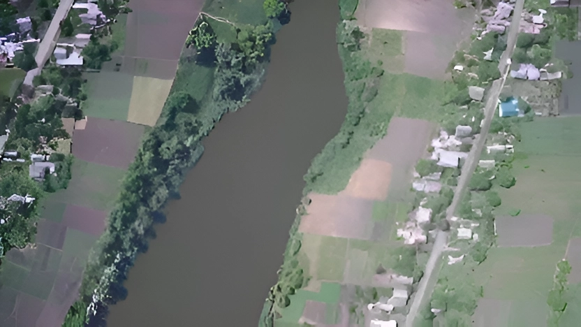
Topographic Mapping
We create reliable topographic maps, contour lines, and 3D terrain models to identify slopes and elevation.
Structural Inspections
We help you conduct building inspections on-demand with zero downtime for your equipment and systems
Environmental Analysis
Our drones are equipped to conduct surveys of forests, agriculture, and other vegetation as part of urban planning or major construction.
Identify Property Boundaries
Classify and subdivide properties based on land type and purpose with accurate measurements for distance and area.
Construction, Real Estate, and Agriculture
Get high resolution imagery with reliable data for feasibility surveys, urban planning, crop health, and progress reports for any industry.
We also provide the following other drone and geo packages:
- Construction Site Survey with Stake Out, Subdivision or Relocation Survey
- Boundary, As-built, GPS, and Cross Section Survey
- Agricultural Survey for Crop Health and Tree Counting
- Volumetric and Distance Measurements
- Aerial Photogrammetry
- Vicinity & Thematic Mapping
- Slope & Erosion Monitoring
- Building Information Models
- Drone Pilot and Operator Training
If you need help finding the right solution for your project, you may send an inquiry to consult with our engineers and pilots.
How are drones used for land, construction, and residential surveys?
Land surveying with unmanned aerial vehicles (UAV) uses new photogrammetry technology in hardware and software to conduct high quality topographic surveys
– faster and cheaper than traditional GIS methods.
When you conduct a survey with UAVs, a drone is deployed to record data from the air by making multiple passes over the project area from multiple angles. These drones are equipped with sensors such as RGB or multispectral cameras to photograph the ground and LIDAR payloads depending on what data is needed.
Each image is tagged with GPS coordinates by surveyors and are stitched together using photogrammetry software to create useful and detailed data visualisations. These are commonly geo-referenced orthomosaics, elevation maps, or 3D models of the project site that let you make accurate measurements for distance and volume.
Lorem ipsum dolor sit amet, consectetur adipiscing elit. Ut elit tellus, luctus nec ullamcorper mattis, pulvinar dapibus leo.
What are the benefits of UAVs in aerial surveying?
The invention of highly robust drones and data analysis software has completely transformed the way we get data and geospatial information system (GIS) surveys. UAVs are now a common method in construction, real estate, power generation, urban planning, and other industries that need up-to-date mapping information for many reasons.
Save time, money, and manpower needed for surveys
Using drones save weeks of time when you need to collect data for large sites. Traditional methods require you to deploy multiple teams and constantly move heavy equipment which increases costs, while UAVs can cover a wide area and capture the same data for massively less time and money.
Map hard to reach areas
UAV surveys reach areas that are near impossible or very time-consuming to cover on foot because they can take off from anywhere and are piloted remotely. This removes any artificial limitations your reports or proposals might have.
Significantly reduce safety risks for personnel
Occupational health and safety risks in unknown terrain or industrial sites are completely eliminated by using drones. Drones can be sent to avoid endangering your surveyors if your project covers steep slopes, roads or highways, heavy machinery, and other high risk areas.
Generate accurate and comprehensive GIS data
Drone flights can be designed to make thousands of measurements in highly detailed increments, instead of measuring only individual points. These can be converted into point clouds, contour lines, orthomosaics, and many other map types for your project.
Improve reports with data visualization and graphics
Drone software lets us present the results of each aerial land survey in a variety of ways. This data can be overlayed into photographs and stylized videos to increase the impact of your reports and proposals.
Remain operational and avoid downtimes
Drones allow your project to continue your operations while they gather data. No need to pull teams away from critical functions or pause construction work to conduct surveys.
Read more: Why drones have become a competitive advantage in Philippine industries
How much do aerial surveys and mapping cost?
The price of aerial surveys and data analysis with UAVs depend on multiple factors including:
- Size of the area to be surveyed (square meters/kilometers)
- Complexity of maps and models required
- Time frame on when output needs to be delivered
All drone services are highly flexible in duration, coverage, and data type and can be designed to meet any specific requirement. If you would like a detailed estimate of how much it would cost to map your project site, simply send us a message and we will send you a free quote.
How to start a drone survey with the AthelstanOne Drone Network:
Our drone services are all designed to be easy, comprehensive, and helpful. It only takes 4 steps from start to finish which includes a free consultation and quote with our pilots and engineers.
To start now with your own aerial survey, send us a message and tell us what you need.
Send us an message with your requirements and our engineers will get in touch to propose solutions and send you a free quote online
We will design a custom flight plan and surveyors will conduct the aerial survey in your site to collect the data you need
Analysts will stitch together all drone footage and convert data into useful maps and information with specialised GIS software
We will send the final topographic maps, 3d models, stylized videos, and other output your project needs