Managed Services

Get expert resources and premium levels of service to take your project delivery or operational effectiveness to the next level. Give your team every advantage. Extend your team’s capacity and capabilities. Make sure you are getting the most out of your software and doing all you can to optimize your work processes.
Professional Services
Solution Implementation, AthelstanOne Advancement and Learning: Get the best results from your AtelstanOne software applications and improve your operational readiness, optimize your business outcomes, and accelerate your time to value. Simplify the complexity of legacy technologies, customized systems, and application integration. Make the best use of people and technology. Specialized consultants help bridge the gaps in your IT resources, skills, and expertise….
Support Services
AthelstanOne GIS Support Policy describes the phases of eligibility for specific support services, and provides the current and planned support status for all versions of AthelstanOne desktop applications, ProjectWise servers and services, and License Administration Services. Understanding the benefits and the support status for your software will help you to proactively manage your licenses for your organization.
Administrative Resources Services
UAV companies and surveying and engineering firms, leveraging reality modeling in-house, can utilize ContextCapture Cloud Processing Service to upload photos and/or point clouds to generate 3D engineering-ready reality meshes, orthophotos, digital surface models, and point clouds dramatically faster than before. This high-performance, cloud-based service automates the production of 3D models of virtually any size or precision without the need for…
Solutions for Architecture and Engineering
As an architectural or engineering firm, you need to deliver the highest quality work on schedule and under budget. Whether you are a single discipline or multi-discipline firm, you need to equip your professionals, empower project teams, and collaborate with other project stakeholders. No matter what your role in project delivery or what type of project you need to address, we can provide your organization with the modeling and project collaboration…
GIS Consulting & Project Management
GIS Needs Assessment & Implementation Planning

A successful GIS start off with an implementation plan. This is a multi-year plan, including a budget that allows for the development of a full scale GIS system from the design to the deployment. AthelstanOne GIS would analyze not only existing data, but also staff, hardware, and software in use. All potential users of the system are interviewed to see how they are leveraging GIS, and what they are trying to accomplish. AthelstanOne GIS we look at the computers they are using, the software, and even peripheral devices such as printers and scanners. Once having analyzed all of the relevant data, AthelstanOne GIS will create a report that details the GIS system and its uses, identifies what is lacking or inefficient, and create a report on how to resolve any issues and make the system much more efficient. AthelstanOne GIS we also recommend data layers that could be created to increase the value of the system, any hardware or software upgrades and even into some options for training staff to better utilize the system. A yearly breakdown of tasks to be completed, as well as the associated costs for budgetary purposes is created. Normally this plan will encompass a five year period of development, with the sixth year migrating into the maintenance phase of the system.
Data Migration Planning
Many GIS systems include data that had previously been developed in an environment other than GIS. This includes data from CAD systems, database systems, and even non-digital data such as paper maps and index cards. This data is often vital to the system and needs to be converted into the GIS environment to retain this information for use in the new GIS system. AthelstanOne has developed in-house procedures for the conversion of these historic data sets so that data is not lost, but is transferred into the GIS system where it can be accessed in more efficient ways.
Database Modeling
AthelstanOne GIS systems are often very unique to the client, therefore, AthelstanOne GIS models each individual GIS database to meet the exact needs of that client. This often includes field creation or manipulation, connections to other layers and external databases, creation of map documents, and other related tasks. It is very important that each client have the ability to use the GIS system to its fullest extent, and this starts with the development of the database model.
Electric Utility Mapping
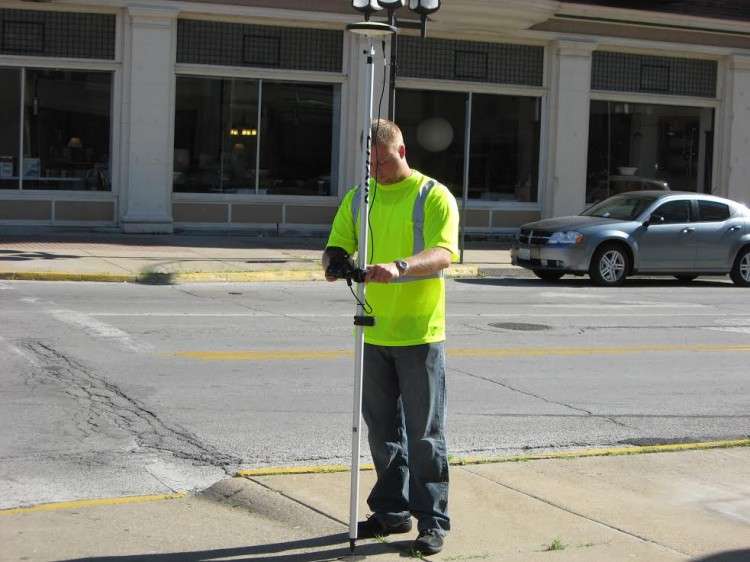
An accurate GPS inventory of assets is the first step in creating a computer based mapping system for managing electric utilities. AthelstanOne GIS has a proven track record for being one of the top firms in the nation in the collection of not only electric distribution systems, but any field inventory type data collection. The ability to collect field data in a timely and cost effective manner, and at the same time holding to our standards for collecting highly accurate data, has proven to be key in maintaining an excellent reputation in the GIS industry.
The use of GPS technology to acquire geographic coordinates, coupled with the ability to capture attributes, can benefit an organization’s spatial data needs. Whether the need is building a database from inception or updating an existing database, GPS data collection provides the accuracy and reliability needed for your GIS project. AthelstanOne GIS uses the most accurate GPS data collection techniques available. With the ability to collect Sub-Centimetre accurate GPS data, this gives the best positional accuracy possible to base the rest of the system on.
Electric distribution systems can be the most complex types of systems to collect. Having the experience necessary to collect this type system is very important. With multiple layers, and an extensive database, AthelstanOne GIS experience with complex data models is a benefit to our client

GIS Data Development
The development of accurate base maps is an integral part of any GIS project. Our staff utilizes the latest ESRI software to generate the most accurate and consistent data products. Our years of experience in data development and our sensitivity to customer needs assure the highest standards in data development. AthelstanOne GIS also offers GPS data collection services to ensure the quality and accuracy of the source data.
Previous GIS Development Projects Include:
Street Centrelines
Address Points / Addressed Structures
Street Sign Inventories
Water & Wastewater Mapping
Jurisdictional boundaries (city, county, police beats, response zones)
Water features such as lakes, streams and rivers
Mile markers
Fire Hydrants
Driveways
Railroads
Township, Section and Range boundaries
GIS Data Maintenance
GIS data maintenance is the key component to any GIS project. Our team can assist you with routine data maintenance or provide occasional GIS support. AthelstanOne GIS clients have the benefit of regular updates performed by our experienced and professional GIS team.
Increased Data Accuracy
Increasing data accuracy involves the correction of existing data, addition of any missing data and the real-time capturing of any data discrepancies. This process eliminates the errors in your GIS data and ensures the effectiveness of data published outside your office.
Reduced Costs & Overhead
GIS Data is maintained by a team of experts which saves your office time and money by not hiring additional staff. Updates are scheduled and the frequency of GIS updates are determined by the needs of each client.

Standardized QA/QC Methodology
AthelstanOne GIS employs a standardized QA/QC methodology that specifically targets each step in the production process and drastically reduces topological and human errors.
Data Ownership
All GIS Data is owned by the client.
An organization is only as good as its people and what they fundamentally believe. Spend some time with us and you will discover who we are.

AthelstanOne Services is leading innovation in Information Technology areas and the Unmanned Aerial Vehicles (UAV or RPAS) commercial services sector using the latest technology and software for aerial inspection and surveying. We use the most sophisticated data analysis and management reporting software to provide our clients with the detailed information they need to make operational and strategic decisions.
AthelstanOne Services was established in 2014 in Abbey Hey Lane Gorton Manchester by Othree Technology, United Kingdom and currently service clients in the Africa, Europe, Africa and the Middle East.
While technology progress has been made for UAV equipment, we recognize that for special and difficult applications in high hazard environments more technology development is required. It is our intent to lead this development to enable full service capability to our clients in the harshest environments.