Licensed & Certified Operators
Highly Flexible Solutions for Any Site
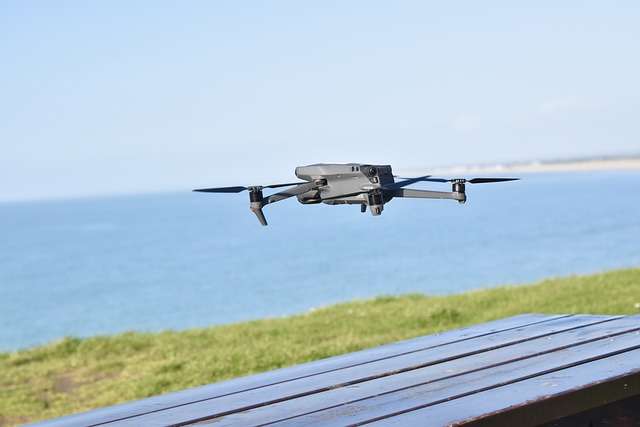
Deployable Anywhere Anytime
Available commercial drone services for construction in AthelstanOne
Below are examples of aerial and land surveys we regularly provide for local clients in Manchester, Sheffield, and London:
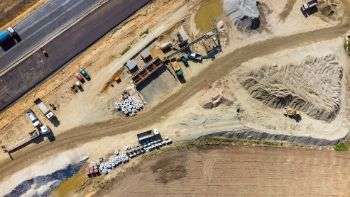
Topographic Mapping
Get complete data about your site with topographic maps, contour lines, 3D terrain models, orthomosaics, and pointclouds – all with high accuracy and reliability.
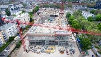
Safer Structural Inspections
Inspect your buildings, equipment, and heavy machinery for cracks and leaks without putting staff at risk through ultra high resolution drone imagery.
Showcase Building Info Models
Bring your construction plans to life and showcase the critical parts of your project with custom animation of your building combined with aerial footage of your site.
Measure Distance & Elevation for Road Planning
Collect the data you need for feasibility surveys or road and urban planning powered by highly reliable aerial surveys.
Site Progress Monitoring
Compare the status of your construction site and track all changes made over time with regular and automated UAV flights – now with virtual tours capability.
Rapid Site Surveys
Avoid project delays with high-speed drones capable of surveying 100-200 hectares per day with high accuracy and reliability.
We also provide the following other drone and geo packages:
- On-demand Geospatial Information Systems (GIS) Analysis
- Construction Stake Out, Subdivision and Relocation Survey
- Environmental and Urban Land Surveys and Analysis
- Custom Videography with Virtual Tours for Reports and Presentations
- Boundary, As-built, GPS, and Cross Section Survey
- Vicinity & Thematic Mapping
- General Aerial Surveys and Site Mapping
- Unmanned Aerial Vehicle (UAV) Pilot and Operator Training
If you need help finding the right solution for your project, you may send an inquiry to consult with our engineers and pilots.
How are drones used for construction surveys and land surveys?
Construction companies and their contractors are the primary customers for drones and other remotely piloted aircraft in the United Kingdom, Nigeria and South Africa.
The biggest reason for adopting this new technology is because drones excel at gathering land data at a large scale and with high accuracy. They do it faster, safer, and with less manpower required than traditional land surveying methods.
This huge savings in time and money have now made drones a competitive advantage in construction locally. The larger the site, the bigger the benefits you get.
Unmanned aerial vehicles (UAV) are also prized in this industry because of their flexibility. All the data they gather by surveying project sites can be processed then used in a wide variety of ways. This includes reliable real-time maps and high resolution video and imagery to help streamline the process of construction planning.
What are the advantages of commercial UAVs to survey for construction and development?
Having reliable geospatial data is an essential step before starting a project, but the resources in time and manpower this requires can often slow down progress. Modern drones solve this problem and make it easier and more efficient to properly conduct a land survey for construction and development.
Here are a few of the major benefits drones give in real estate, roads & highways, energy, and other construction-related industries:
Reliable speed and performance on all terrain and environments
Unlike old survey methods, drones are not limited by challenging, unknown, or dangerous terrain. They can cover hard-to-reach slopes, active highways, and any other dangerous environment without putting staff at risk.
Fewer and smaller teams needed to survey large sites
A single commercial drone can cover 100 hectares to 200 hectares in a single day and collect large amounts of in-depth data. This means less manpower need to be allocated for surveys so you can keep your team focused on making progress on the actual construction.
Strengthen occupational safety for on-site staff
Drones ensure that workplace health and safety in your project site is not put at risk. They are controlled remotely from great distances which means high-risk areas like active highways and high slopes, as well as areas with heavy machinery can be surveyed and inspected safely.
Collect highly-accurate geo-data
Sensors equipped to UAVs and other remotely piloted aircraft are extremely sensitive and accurate when it comes to gathering data. Flights can be automated to ensure surveys are done consistently every time and get high quality data for contour lines, topographic maps, and other output.
How much does drone survey and land mapping cost?
The price of construction surveys and data analysis with UAVs depend on multiple factors including:
- Size of the area to be surveyed (square meters/kilometers)
- Complexity of maps and models required
- Time frame on when output needs to be delivered
All drone services are highly flexible in duration, coverage, and data type and can be designed to meet any specific requirement. If you would like a detailed estimate of how much it would cost to map your project site, simply send us a message and we will send you a free quote.
How do you start a road or construction survey?
Our land surveyor services are all designed to be easy, comprehensive, and helpful. It only takes 4 steps from start to finish which includes a free consultation and quote with our engineers and pilots.
Send us an message with your requirements and our engineers will get in touch to propose solutions and send you a free quote online
We will design a custom flight plan and surveyors will conduct the aerial survey in your site to collect the data you need
Analysts will stitch together all drone footage and convert data into useful maps and information with specialised GIS software
We will send the final topographic maps, 3d models, stylized videos, and other output your project needs